Just to give you an idea I post here bottom the map of the battle according to the Osprey Campaign Series "Rossbach and Leuthen" where the real dimensions of the battle of Leuthen are easily visible.
Saturday, July 30, 2016
1757 LEUTHEN 1:1 RATIO - Part 1
Just to give you an idea I post here bottom the map of the battle according to the Osprey Campaign Series "Rossbach and Leuthen" where the real dimensions of the battle of Leuthen are easily visible.
Wednesday, July 27, 2016
1099 CRUSADE - ROAD TO JERUSALEM
Thursday, July 21, 2016
1757 SYW - PRUSSIAN 8th REGIMENT "VON GEIST"

Info from Kronoskaf:http://www.kronoskaf.com/syw/index.php?title=Amstell_Infantry

- since June 25 1754: Georg Friedrich von Amstell (killed in action during the battle of Prague on May 6 1757)
- from May 12 1757: Baron Karl Ferdinand von Hagen, also known as “von Geist” (died on February 19 1759 from wounds received at the battle of Hochkirch)
- from February 25 1759 to December 13 1769: Julius Dietrich von Queiss

Top: the 5 colours of the Second Battalion marching aside the coloumn
Service during the Seven Years War
In 1756, the regiment was considered as the best Pomeranian regiment and was initially stationed in East Prussia. In December, it was transferred to Lusatia.In the Spring of 1757, the regiment took part in the invasion of Bohemia. On April 21, at the Combat of Reichenberg, the regiment was deployed on the right wing of the first line of Duke of Brunswick-Bevern's force. On May 6, the regiment took part in the Battle of Prague where it was deployed in the first line in the Duke von Braunschweig-Bevern's Brigade. Its colonel was killed during the battle. On November 22, the regiment took part in the Battle of Breslau where it was deployed in Ingersleben's Brigade, in the first line of the infantry centre. On December 5 at the Battle of Leuthen, the regiment was deployed in Münchow's Brigade in the first line of the infantry centre.
 In the Spring of 1758, the regiment took part in the invasion of Moravia and in the Siege of Olmütz. On October 14, the regiment took part in the Battle of Hochkirch where it was initially deployed in the village and immediately to its left. Its second battalion vainly tried to recapture the Prussian battery planted near Hochkirch. During this battle, its colonel, Major-General von Hagen (aka von Geist), was mortally wounded.On September 17 1760, the regiment was present at the Combat of Hochgiersdorf. On November 3, it took part in the Battle of Torgau where it distinguished itself in the attack of the Süptitz Heights but was virtually annihilated.As it possible to see here, the unit can be deployed in column or in line, exactly as in the reality. Every base represents a company (8 per battalion) with a front of 4/5 stands of 4/5 papersoldiers each on 3 ranks; the stands have a magnet to glue them to a bigger base with iron inside, giving the possibility to play and remove one single stand (4/5 men) with a very very short time for deploying and entire battalion or even an entire regiment, as shown
Colours
Colonel colour (Leibfahne): White field with black flames. Centre device consisting of a black medallion surrounded by a golden laurel wreath and surmounted by a golden crown. The medallion is decorated with a golden eagle holding a sword and lightning bolts surmounted by a white scroll bearing the golden motto "Pro Gloria et Patria". Corner monograms (crowns, laurel wreaths, FR ciphers) and grenades in gold.Regimental colours (Kompaniefahnen): Black field with white flames. Centre device consisting of a white medallion surrounded by a golden laurel wreath and surmounted by a golden crown. The medallion is decorated with a black eagle holding a sword and lightning bolts surmounted by a black scroll bearing the golden motto "Pro Gloria et Patria". Corner monograms (crowns, laurel wreaths, FR ciphers) and grenades in gold.
the 10 colours of the complete regiment.
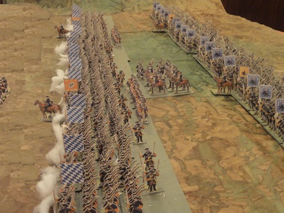
This pictures are intented to show you the possibilities of papersoldiers in a 1:1 ratio; here it's introduced 2 battalions of the 8th Regiment at the Battle of Leuthen;
There is a total of about 1.100 papersoldiers (still drummers and some NCO's and Officers to be done to complete); every battalion is about 60/70 cm wide;
Close view

The 2 Battalions in line
Wednesday, July 13, 2016
1805 NOVGOROD REGIMENT 2
today it's very hot (35!) and so I decided to refresh my thoughts with some pictures from the cold hills of the Battle of Austerlitz back in 1805.
Finally I realized a Major of the Novgorod Regiment. This figure was particullary difficult to me, due to the correct proportion of the horse and man.
On the background you can see also a well, guarded by some men of the Regiment
Saturday, July 2, 2016
PAPER SOLDIERS vs NORMAL MINIATURES
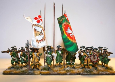
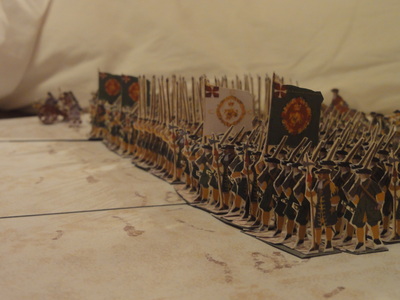
I present here two images of the same unit — the Danish Fynske Regiment at the Battle of Lund (4 December 1676) — shown in two different versions.
In the upper image, the regiment is represented as a single battalion, while the lower image shows the same battalion depicted using paper soldiers.
The first image is taken from the Black Powder Games website.
The unit shown in the upper image consists of 12 musketeers, 4 pikemen (one of whom is an officer), 2 colour bearers, 1 NCO, and 1 drummer, for a total of 20 figures, representing approximately 320 real soldiers. This corresponds to a ratio of 1 figure = 16 men, which is already a very reasonable proportion.
Nevertheless, I believe that this representation still lacks realism. It is, for example, impossible to reproduce the two guns positioned on the flanks of the unit, which were extremely important in battles of that period. Moreover, the colours alone represent 10% of the total manpower, which is clearly disproportionate.
There is no doubt that each individual figure is beautifully painted and represents a true masterpiece of miniature art. The real question, however, is whether the player prefers to use a stand with a limited number of figures to symbolically represent a unit—leaving its real composition to be resolved by dice—or instead prefers a more faithful and realistic representation of a single battalion, even if the individual figures are less refined.
It is also worth noting that paper soldiers, when deployed together, have a strong visual impact and can closely reproduce the appearance of an army as it would have looked on the battlefield.
The main drawback is that a very large battlefield is required to display all the units properly. That said, the Battle of Lund (1676) offers a fantastic opportunity to recreate a battle at a 1:1 scale, considering that units were typically deployed in six ranks and that the overall numbers involved were relatively limited.
By contrast, it would be impossible to recreate the Battle of Borodino, for example, both because it would require more than 200,000 paper figures and because the space needed would be enormous. In such cases, a reduced scale representation would clearly be more appropriate.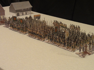
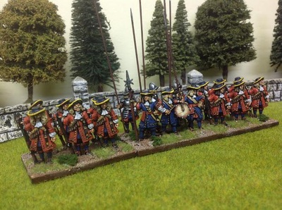
In the images above, my intention is simply to compare the visual impact of a battalion from the same historical period, not to criticise one representation over the other, but to allow for a free and informed choice.
The most evident difference lies in the number of figures. On the left, there are 317 paper soldiers; on the right, only 18 metal figures. From a purely visual standpoint, the metal figures are undoubtedly more charming when observed individually: the uniforms are highly detailed and beautifully painted. However, when viewed as a whole, the overall impression is rather weak. More than a battalion, it looks like a small group of friends gathered for a day out, rather than a formed military unit.
On the left (and here I openly admit my preference for paper soldiers), the large number of figures allows the player to represent the internal structure and details of a real battalion: fifers, regimental guns, grenadiers, sappers, pikemen, and NCOs are all present. This provides a much more convincing impression of what a unit truly looked like in those glory days, and conveys a far more realistic sense of mass, order, and battlefield presence.
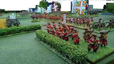
With traditional miniatures, each stand essentially represents an abstract idea of troops, regardless of the actual number of soldiers. In contrast, with paper soldiers, the real composition of a unit becomes the most important factor, allowing battles to be resolved as accurately as they would have occurred in reality.


